10 Things You Can Do with the new and improved Catawba Riverkeeper app!

August 25, 2022

Catawba Riverkeeper is proud to announce the launch of our new and improved app. Our app is now available for FREE for both iPhone and Android.

10 Things You Can Do with the Catawba Riverkeeper App

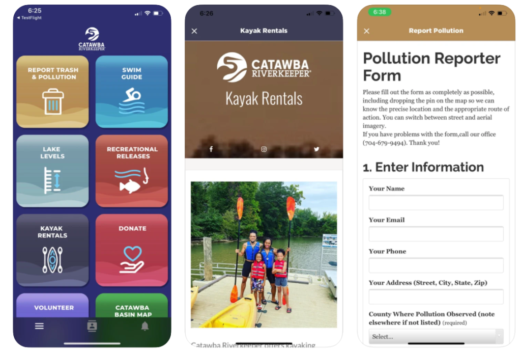
If you’re out and about and see a bunch of trash or something that looks concerning, you can report it to the Riverkeeper immediately. With the app, you can enter information about the trash or pollution you see. You can even send Catawba Riverkeeper GPS coordinates with the push of a button. By reporting trash and pollution, you’re acting as eyes for the Riverkeeper and a voice for the River.

You’ll definitely want to download the app before summer starts so that you know which popular swimming areas met bacteria standards and which areas to avoid. Catawba Riverkeeper tests about 60 sites each week. Results are posted on Fridays so that you can make good decisions about weekend swimming.

Does the lake seem high or low to you? Find out with one tap. Our app links you to Duke Energy’s lake levels page. You’ll always know if the lake is at, above, or below “full pond.”

This one’s for the paddlers and the tubers! You can plan your trip around Duke Energy’s recreational releases. Never be surprised by the flow of the river again.

Catawba Riverkeeper will offer a variety of kayak opportunities starting in May. Here you’ll find out where and how you can rent a kayak or book a half-day trip.

Want to support Catawba Riverkeeper’s mission to protect our waterways. You can give through the app. Every dollar gets us closer to our vision of clean, plentiful water for all.

The app can connect you to general volunteer information and to the volunteer interest form. Completing the volunteer interest form helps us get to know you better and automatically puts you on our volunteer email list.

Not just for map Geeks! You can see the major waterways of our basin, permitted wastewater discharges, drinking water intakes, recreation access areas, and more! You can even find your state representatives.

See a buffer violation? Is an active construction site not following the required sedimentation measures? Report your concern to the proper authority. Our guide helps you figure out who to contact.

We’ve got t-shirts, sweatshirts, hats, stickers, bracelets, and more in our online store. All of our apparel is made by local company, Recover Brands, who uses recycled materials to make their super soft shirts.

You can use the app as a guest, but we encourage you to make a profile. With a profile, you’ll get notifications tailored to you.

How to get the app on your smart phone or tablet:

Search “Catawba Riverkeeper” in your app store or click on either icon below.

May 27, 2026
On the evening of May 26th, 2026, Catawba Riverkeeper Brandon Jones attended the Charlotte City Council Public Meeting. At this meeting, he shared our organization's comments on the proposed 150-day data center moratorium. These comments can be read below. "The Catawba Riverkeeper Foundation is a member-funded environmental nonprofit that educates, advocates, and protects the Catawba-Wateree River and all its tributaries. Our organization represents over 8,000 active members and nearly 3 million citizens who rely on the watershed for drinking water, recreation, and electricity. We are concerned that the growth of local data centers may overallocate our limited resources and decrease our ability to respond to drought. We appreciate the opportunity to comment on the proposed 150-day moratorium and strongly support the staff's recommendation to adopt it. Additionally, if adopted, we recommend that the study consider a tiered approach, transparency, and net water consumption. For our water resources, the most important data center metric is net water use. A 400 MW facility—like the one now under construction on Moores Chapel Road—may actually evaporate more water indirectly than directly for cooling. The nearby Catawba Nuclear Station uses approximately 30 MGD to produce 2,300 MW or 5.2 MGD from Lake Wylie per 400 MW. However, without transparency and reporting, it is difficult to know the current impact of these data centers and almost impossible to accurately forecast the industry's future. The most accurate forecast of our region's water resources is the Catawba Wateree Water Management Group’s 2026 Integrated Water Resources Plan. Unfortunately, this plan explicitly does not include increases in water use from data centers due to limited reliable information. It is absolutely critical that our community has accurate information. We need full transparency on the planned electrical and water use of large data centers. A ban of nondisclosure agreements between elected officials and developers could help alleviate suspicion and allow communities to make informed decisions about tradeoffs. The potential direct and indirect impact s of a project should be modeled by the CWWMG to determine its actual impacts. Those impacts could be mitigated by funding water conservation projects, as some data centers have already proposed. Once operating, we need reporting on the actual water and energy use. The cumulative impact must be understood to ensure capacity and resiliency. Water withdrawers from the Catawba utilize a Low Inflow Protocol during drought to help stretch the available supply. Large data centers need conservation plans that comply with this plan. It is hypocritical to ask residents and some businesses to restrict water use while permitting facilities that cannot or will not do the same. Most years, there is plenty of water for drinking, irrigation, ecological flows, and industry in the Catawba. However, droughts such as 2001, 2007, and today expose our vulnerabilities. These droughts are more likely in a warming climate, and we are becoming less resilient with a growing population and industrial demands. Sustainable water management requires careful planning and robust coordination between users, including data centers."
By Susannah Bryant March 19, 2026
Greg Nance has had his boots on the ground since the storm subsided.
February 19, 2026
Live staking is a streambank restoration approach that reduces erosion and sediment pollution. This is the practice of planting dormant branch cuttings of native plants along streambanks (also known as riparian zones) to help hold soil in place along the waters' edge. Live stakes are planted along with native plant seeds and shrubs to create riparian buffers, which help prevent sediment from becoming a stream pollutant by securing the soil in place with good root systems. Riparian buffers also filter out other pollutants, such as chemicals, oils, fertilizers, and trash, before they enter our waterways.