Great Falls Whitewater Project
Updates on the Great Falls Project to restore aquatic habitat and provide recreational opportunities
Updates as of January 2023:
- A group of professionals are continuing to clear trees/hazards from the long reach bypass
- They are doing continued trial runs to assess safety at various water levels
- Dam construction is complete
- Emergency response training will begin in February
- The island trail is still set to be completed in March 2023
- The channels are not open for public use until March 2023
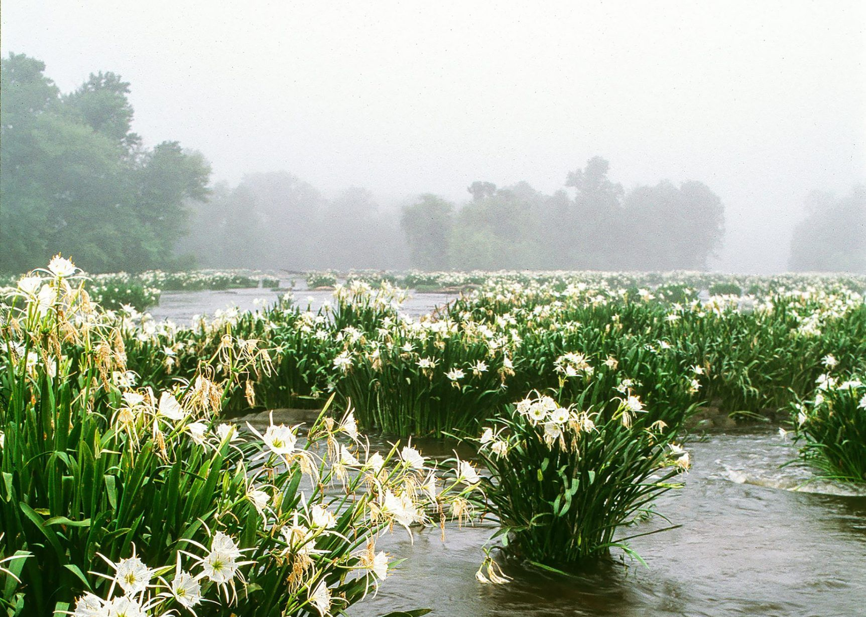
The Great Falls Project is a multifaceted endeavor to restore aquatic habitat and provide recreational opportunities. It began with Duke Energy’s receipt of a new license in November 2015 within the Town of Great Falls for the area from the Fishing Creek Reservoir to the bottom of the Cedar Creek Reservoir. The project includes modifications to two dams - the main Great Falls Diversion Dam in the north at the Fishing Creek Reservoir just before the long bypass (to the east, river left), and the smaller dam to the south at the Great Falls Reservoir just before the short bypass (to the west, river right).
The northern dam is being adjusted in two ways. Prior to this project, there was no minimum flow requirement for the dam which meant that the long bypass was left dry except during high flows. Thus, on one side, there will be a point that will allow for a minimum flow of water at all times. This is great news for the river ecosystem as it will return water flow to a more natural level which will restore habitat that has not been seen in at least one century. This will be beneficial to both plants and animals, hopefully giving native species a greater chance at life. It also allows for the recreational use of that path which was previously too unsafe for most paddlers. On the other side, a ramp-like structure is being installed that will be used during the higher recreational flow releases for boaters to then navigate the 2.25 mile stretch below. Construction on the dams were expected to be completed by December 2022, but heavy rains have pushed this out to February 2023. There will be an operational testing period until the official completion deadline at the end of April 2023 and an additional trial operations period through October 2025 to confirm the proper flow rates and times.
The southern dam adjustments will also allow for a regular flow of water, recreational releases, and flood management. Aptly named the “short reach” as it is only 0.75 miles long, the faster drop in elevation from the dam to where the waterway meets up with the long reach will provide for more rapid, higher-class whitewater. As with the long reach, the ecosystem will benefit from this renewed flow of water. Construction on the short bypass access area cannot begin until construction ends at the long bypass, however, Duke hopes to have this completed by mid-summer 2023.
In addition to the dam modifications, this project includes:
- the installment of a parking area (Nitrolee Access) and restoration of the historic nitrogen manufacturing building to be completed at the end of October 2022;
- an extension of the Carolina Thread Trail with construction set to begin soon and be complete by early summer 2023;
- a new visitor center which will be the renovated Company Store Building (Belk) with construction to begin in fall 2022 and be complete shortly after the recreational flows begin in 2023;
- the designation of a new State Park on Dearborn Island. The Island is currently inaccessible on foot, so a pedestrian bridge will be built connecting the northwestern side of the island to a parking area. The park itself is currently set to open in 2025, although the bridge construction will begin in 2024 and will not be complete until 2027; and
- a kayak launch near the pedestrian bridge, construction to begin at the same time as the bridge in 2024.
Beyond the immediate scope of this project, design will soon begin on the trails that will lead to the railbed, pedestrian bridge and kayak launch. The goal is to have the trails and roadways completed at the time the State Park opens. Further, the Mudcat Inn access area (below the Great Falls Dam) has a deadline date of 2027, however Duke has said they plan to have it completed before that date. Lastly, a fishing platform in the area of the tail race of Fishing Creek Dam has a deadline date of 2027, although Duke has indicated it will probably be earlier.
Catawba Riverkeeper is working closely with stakeholders and participating in the Planning Committee meetings for this endeavor. It is our hope that the increased recreational access to this river and renewal of water flow will raise peoples’ awareness of how important it is to care for our resources. It is a great opportunity to be a part of this project, help promote environmental protection, and document the ecosystem restoration that will occur as a result.
- Planned enhancements PDF - https://www.duke-energy.com/_/media/pdfs/community/lakes-and-rec/catawba-wateree/great-falls-enhancements-flyer.pdf?la=en
- News video, Feb 2021 - https://www.wsoctv.com/news/local/whitewater-project-coming-sc-could-boost-eco-tourism/UHD7XGEW2FCFJO6QASPW6N3WWM/
- News video, Oct 2021 - https://www.youtube.com/watch?v=3mxhtz9OEUg
- Another news video, Oct 2021 - https://www.cn2.com/effort-to-bring-life-back-to-great-falls-through-nature-based-tourism/
- Go Magazine article, Nov 2021 - https://go.carolinas.aaa.com/go-magazine/online-exclusive/great-falls-sc-white-water-recreation/
- News, May 2022 - https://www.americanwhitewater.org/content/Article/view/article_id/k5txZzh2n7TRJJfutbmEh/
- Update doc, Jun 2022 - https://elibrary.ferc.gov/eLibrary/filelist?accession_num=20220613-5022
- Duke site video update, Jun 2022 - https://www.youtube.com/watch?v=0KMb8RxFLCM
- News article Jan 2023 - https://www.wsoctv.com/news/local/whitewater-attraction-chester-county-getting-close-completion/KZ4ZH7JYRBHOVFPLBWEM7PUUNQ/